
- 58 parks
- 30 hotels
- 7 RV parks
- 225+ restaurants
- 36 coffee shops
- 21 brew pubs / wine bars
- 10 bike shops
- 4 Farmer’s Markets and much more
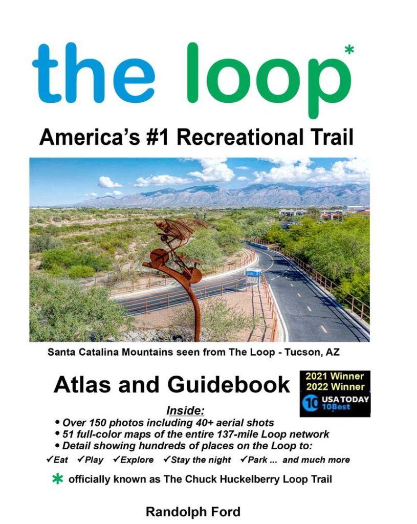
The 8 x 10 soft cover format is the perfect size for ease of use. The Loop has been described as a 136-mile long linear park with hundreds of things to see and do. Use this guide like a Treasure Map to find the Loop’s many pieces of public art; the dozens parks and historical sites; or the perfect Loop food stop. What a surprise to discover this amazing oasis woven around and through a major metro area. Tucson’s beautiful corner of the Sonoran desert is on full display everywhere you look. Enjoy the Guidebook’s hundreds of color photos and the more than 40 aerial trail views. Better still, come with friends or by yourself to explore this amazing vehicle-free shared-use trail system first-hand.
- 58 parks
- 30 hotels
- 7 RV parks
- 225+ restaurants
- 36 coffee shops
- 21 brew pubs / wine bars
- 10 bike shops
- 4 Farmer’s Markets and much more
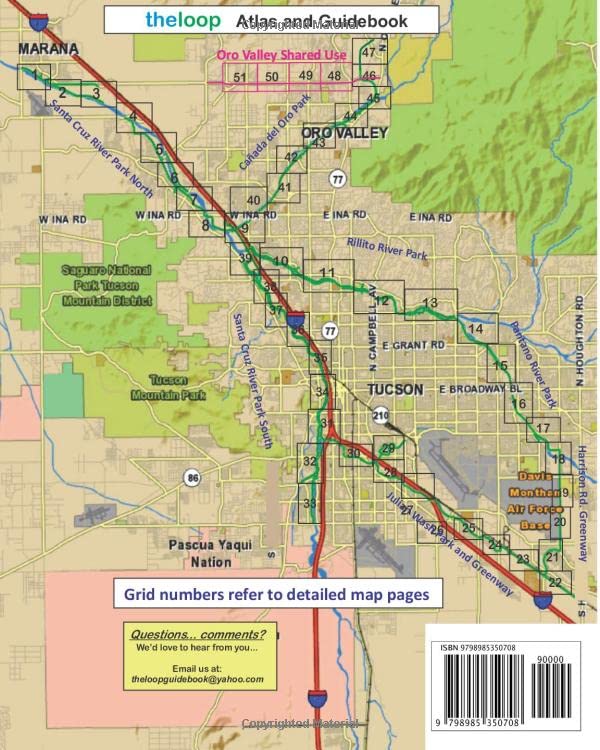
Discover the ultimate reference atlas and guide about The Loop…Tucson’s incredible 137-mile network of wide, paved hiking, biking, and horseback trails. The Loop traverses lush open desert and along the banks of five local watersheds. The network of trails spread over an area spanning 30 miles east-to-west and 45 miles north-to-south. Mountain vistas, cactus forests, and lush riparian habitat is everywhere you look along this masterpiece of connected trails. It was no surprise when readers of USA TODAY 10Best.com voted the Loop as America’s #1 Recreational Trail System in 2021 and then again in 2022! Use this full-color Atlas and Guidebook for a visit or to plan your Destination Vacation. There are 51 detailed full-color trail map pages, each detailing several miles of trail. For each map page, there is a facing page that describes what you’ll encounter on that section of trail.
Author Randy Ford downsized a few years ago and wound up living right next to the amazing 136-mile Pima County shared-use Loop Trail. After 30 years of desert living, a previous knee injury and a heart valve defect had taken their toll. Now retired, he is once again a daily cyclist for rehab and sanity preservation. The Loop was like a treasure for him to unwrap, explore, and share. Ford has been a writer of non-fiction articles, books, and a number of short stories up until now. The Loop guidebook is his first foray into outdoor adventure and travel.
Follow along and see how Randy’s love of cycling and the Loop have combined to become the Loop’s first Atlas and Guidebook. The heart and soul of the guide is the detail found in the maps of the trail network’s every mile. You will discover all the highlights along the way through photos, and over 40 aerial trail shots. Now the magic of discovering where to find a good beverage, a meal, a park, restrooms, trail access parking, and lodging is right at your fingertips.
Discover the ultimate reference atlas and guide about The Loop…Tucson’s incredible 137-mile network of wide, paved hiking, biking, and horseback trails. The Loop traverses lush open desert and along the banks of five local watersheds. The network of trails spread over an area spanning 30 miles east-to-west and 45 miles north-to-south. Mountain vistas, cactus forests, and lush riparian habitat is everywhere you look along this masterpiece of connected trails. It was no surprise when readers of USA TODAY 10Best.com voted the Loop as America’s #1 Recreational Trail System in 2021 and then again in 2022! Use this full-color Atlas and Guidebook for a visit or to plan your Destination Vacation. There are 51 detailed full-color trail map pages, each detailing several miles of trail. For each map page, there is a facing page that describes what you’ll encounter on that section of trail.
About the Author
Author Randy Ford downsized a few years ago and wound up living right next to the amazing 136-mile Pima County shared-use Loop Trail. After 30 years of desert living, a previous knee injury and a heart valve defect had taken their toll. Now retired, he is once again a daily cyclist for rehab and sanity preservation. The Loop was like a treasure for him to unwrap, explore, and share. Ford has been a writer of non-fiction articles, books, and a number of short stories up until now. The Loop guidebook is his first foray into outdoor adventure and travel.
Follow along and see how Randy’s love of cycling and the Loop have combined to become the Loop’s first Atlas and Guidebook. The heart and soul of the guide is the detail found in the maps of the trail network’s every mile. You will discover all the highlights along the way through photos, and over 40 aerial trail shots. Now the magic of discovering where to find a good beverage, a meal, a park, restrooms, trail access parking, and lodging is right at your fingertips.
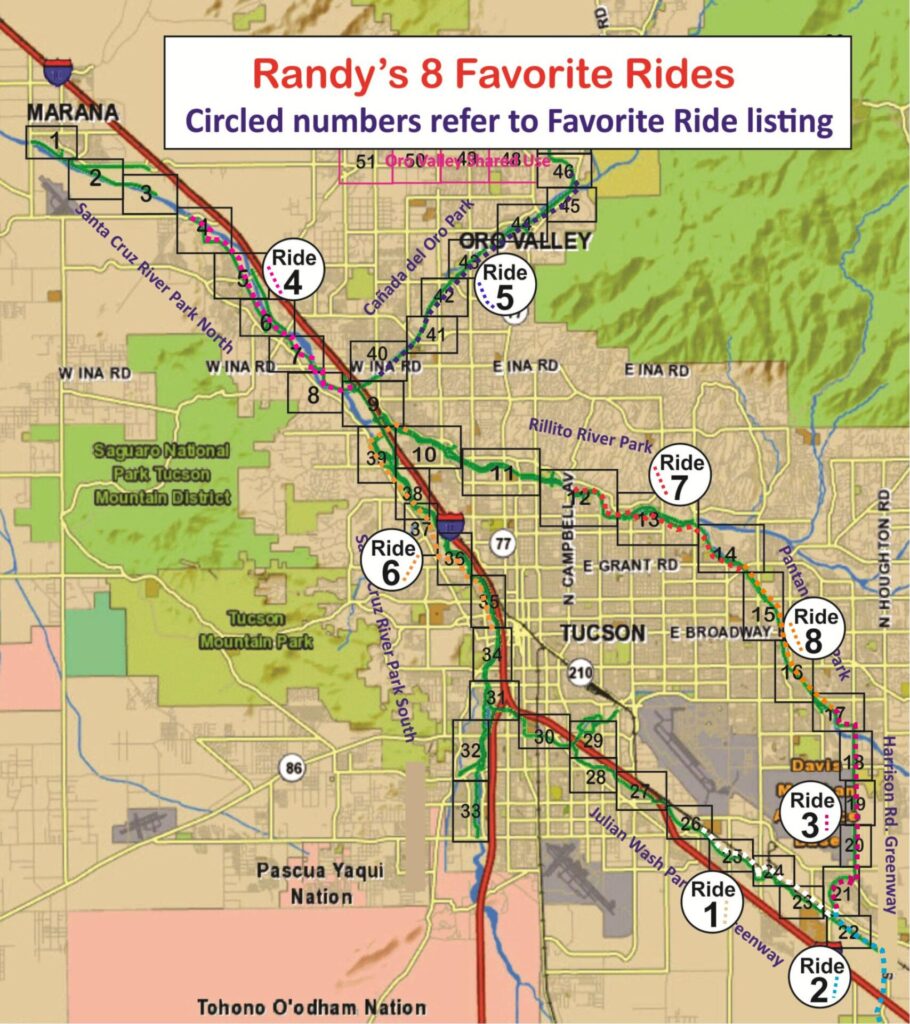
| Ride | Ride Name | One Way Distance | Loop Sections | The Loop Book Page | Park/Start | End | Description/Highlights | Where to Park |
| 1 | Joining Hands (desert /grasslands) | 7.3 mi | Julian Wash Greenway | 23 thru 26 | Rita Rd and RR Tracks (to NW) | Thomas Jay Regional Park | Joining Hands Arch 2.1 mi Thomas Jay Park 5.6 mi TTT Truck Stop & Crazy Horse RV is 1/3 mi S of TJ park | (S) Dirt Lot SE corner Rita Rd & RR Tracks (N) Thomas Jay Park Lot |
| 2 | Southern Tip of the Loop (desert /grasslands) | 6.0 mi | Julian Wash Greenway | 22 | Rita Rd and RR Tracks (to SE) | South of Pima County Fairgrounds on Houghton Rd. | Ride all the way south of Pima Cty. Fairgrounds | (N) Dirt Lot SE corner Rita Rd & RR Tracks (S) No parking |
| 3 | Fantasy Island 3.5 mi. natural desert 4 mi. public bike Lane (desert /grasslands) | 7.5 mi | Houghton Rd Greenway | 17 thru 21 | Michael Perry Park | Rita Rd and RR Tracks | Fantasy Island N Lot 3.5 mi Fantasy Island S lot 5.5 mi Rita Ranch / RR Tracks @7.5 mi | (S) Ted Walker Park Parking Lot (N) Avra Valley Road Dirt Lot 1/4 mi W of I-10 |
| 4 | Marana Falls (Ina Rd) to Avra Valley (riparian river bank and desert hillside) | 8.5 mi | Santa Cruz North | 4 thru 9 | Ted Walker Park Lot | Avra Valley Rd Loop Parking Lot | Falls under Ina Rd. Bridge 2.0 mi Silverbell Crossroad Park 3.0 mi El Rio Preserve Park 7.5 mi Saguaro-studded hills/end 8.5 | (S) Horizon Hills Parking Lot (N) Oro Valley Marketplace |
| 5 | Oro Valley/Pusch Ridge Tour (riparian riverside/suburban desert/grassland) | 10.0 mi | Canada del Oro Wash | 39 thru 46 | Horizon Hills Parking Lot | Oro Valley Marketplace | Christina-Taylor Green Park 1.5 mi Riibe Ranch Shopping 7.5 mi Steam Pump Ranch 8.0 mi Catalina State Park 9.0 mi Oro Valley Mktplace 9.5 mi | (N) Camino de La Tierra Parking Lot (S) Many parking areas near Loop around Mercado San Augustin |
| 6 | Mercado San Augustin Tour Hollywood Barrio (riparian riverside and urban venues) | 10.3 mi | Rillito River Santa Cruz S. ( use W. bank) | 9, 39 – 34 | Camino de La Tierra Parking | Mercado San Augustin or Msa Annex area | I-10 Upass to S Criz junc. 0.8 mi Sunset bridge crossing 1.7 mi Silver bell Lake 4.0 mi Riverside Park – Grande Ave 8.8 mi Mercado San Augustin 100 mi Msa Annex 10.3 mi | (S) Many parking areas near Loop around Mercado San Augustin |
| 7 | Coffee Xchange coffee Run (N) (riparian riverside and urban venues) | 7.5 mi | Rillito River, Pantano River | 12 thru 14 | St Phillips Plaza | Coffee Xchange Tanque Verde | Brandi Fenton Park 2.0 mi Didge river Crossing 2.5 mi Ft Lowell Park 5.6 mi Tanque Verde Bridge Cross 7.5 mi | (N) St Phillips Plaza S of Homewood Hilton (S) Coffee Xchange Tanque Verde |
| 8 | Coffee Xchange Coffee Run (S) (riparian riverside and urban venues) | 5.5 mi | Pantano River Harrison Greenway | 14 thru 17 | Michael Perry Park Parking | Coffee Xchange Tanque Verde | Broadway Bat Bridge 2.8 mi Tanque Verde Bridge Cross 5.5 mi (stay on E bank of Pantano | (N) Coffee Xchange Tanque Verde (S) Michael Perry Parking Lot |
The Loop, food, RV parks, coffee shops, and more!
Need it Fast!
Locations for Local Pickup
Pedego Oro Valley
Oro Valley Marketplace
11835 N Oracle Rd Suite 197, Oro Valley,
AZ 85737
Phone: (520) 395-2671
Pedego Tucson
St Phillips Plaza
4320 N Campbell Ave #128, Tucson, AZ 85718
(520) 441-9782
Tucson / Lazydays KOA Resort
5151 S Country Club Rd Tucson, AZ 85706
(520) 799-3701
tucsonstore@koa.net
Sabino Cycles
7045 E Tanque Verde Rd, Tucson, AZ 85715
(520) 885-3666
Broadway Bicycles
140 S Sarnoff
520-296-7819
Pima Street Bicycle
5445 E Pima St, Tucson, AZ 85712
(520) 326-4044
Bicycle Ranch Tucson
7090 N Oracle Rd Ste 156, Tucson, AZ 85704
(520) 219-4311
South Forty RV Ranch
3600 W Orange Grove Tucson 85741
(520)297-2503
Catalina Brewing Co
6918 N Camino Martin 85741
(520)329-3622
Antigone Books
411 N 4th Ave, Tucson, AZ 85705
Phone: (520) 792-3715